When flying, I love having a window seat especially when take off or landing is during daylight hours and the skies are clear. When I used to fly regularly between Edmonton and Toronto, I was able to pick out locations, especially when flying over Ontario and when the plane was descending towards Pearson International Airport at Toronto. The descent would usually begin over Georgian Bay, and I could pick out Owen Sound and the various communities in view from the window. Often, we’d fly in a path that would lead us almost directly over Orangeville or just to the east and I could even see and identify rivers and bodies of water I fish, and if on the left side of the plane, communities including Newmarket, Aurora, and Richmond Hill.
On my recent flight to Athens, Greece, we were lucky to have very clear skies on the descent into the Athens international airport. We flew down the east side of Italy and then across the Mediterranean and got a great view of what I believe were the Ionian Islands before passing over the northern Peloponnese region. When we flew over the Saronic Gulf, I was pretty sure we had just flown south of Corinth and in the distance, I could make out the canal.
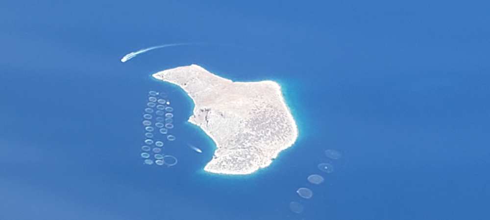
As we passed over the Saronic Gulf, I saw the island, pictured above and what appears to be two boats traveling at a fairly high speed. What seemed really odd to me were the circles in the sea to the south and to the west of the island. I have no idea what they are but my curiosity about this island got the better of me. A few days ago, while going through my photos, I was able to match this island with Google maps and their satellite view to what was identified as the Island of Vrachonisis Petronisis. When zooming in, the island basically looks like a big rock – but it does have at least two outposts of some sort, perhaps resting or processing places for fishermen.
If you view the Google satellite view, you can zoom in and see two docks, both with a boat each tied up to it. One is up in the north west and the other is in the south west of the island. The post in the north has several buildings which are easily made out while the outpost in the south appears to be a bit more cluttered and its hard to make out what exactly is there.
You can see the satellite view here.
With the satellite view, I’m still unable to make out the circles in the sea that can be seen in my photo, above. If you have any ideas, please let me know in a comment. I am thinking that they are probably something to do with fishing, but I can’t be sure.